Your Cart is Empty


Southern California isn't just beaches and Hollywood. It's a 4x4 paradise that'll make your truck or off-road rig earn its keep. From the towering pines of Big Bear to the otherworldly landscapes of Anza-Borrego, these Southern California off-road trails serve up some of the most diverse and exciting off-road adventures in the country. Whether you're looking to test your rig's limits or just want to cruise through stunning scenery with spectacular views,California off-road trails deliver the goods for off-road enthusiasts of every skill level.
California stands out among off-road destinations for several key reasons that make it a top destination for 4x4 enthusiasts. California’s diverse terrain, year-round accessibility, options for different skill levels, proximity of trails to major cities, and an OHV minded community all make for an excellent destination. Let’s dive into these and see why Southern California is really in a league of its own when it comes to off-road.
Looking for a complete California Off-Road Overview? Check out our California Off-Road Trails Overview
California's geography reads like a 4-wheeler's wish list. Within a few hours' drive, you can tackle snow-covered mountain passes, navigate desert washes, crawl over granite boulder fields, and explore slot canyons carved by ancient floods. This variety means you'll never get bored, and your rig will face every challenge imaginable across diverse terrain and recreational activities.You often can even find two or more of these terrains in a single day trip.
While other states' trail systems shut down for the winter months, Southern California keeps the adventures rolling. Desert trails stay accessible through the cooler months, and certain mountain trails offer snow wheeling for those brave enough. Spring brings wildflower blooms that transform desert landscapes, while fall offers perfect temperatures across all regions for off roading adventures. Regardless of the season you can find many trails to cruise.
Southern California doesn't discriminate. Brand-new to 4-wheeling? There are plenty of scenic dirt roads that welcome stock SUVs or trucks. Running a built rig with lockers and armor? Legendary trails like John Bull will test everything you've got. Most areas offer easy trail options, as well as intermediate and advanced routes, so mixed groups can find their sweet spot regardless of experience levels in the same general area. For example, Big Bear offers trails for all levels of experience.
Unlike some states that require a multi-day trip to access the off-road trails, many of Southern California's best OHV trails sit within a short drive of LA, San Diego, and/or the Inland Empire. This close proximity means weekend warriors can hit the trail Saturday morning and be home that night.
California's off-road recreation community runs deep, with established clubs, volunteer trail maintenance programs, and well-marked route systems. California State Parks, US Forest Service, and Bureau of Land Management maintain extensive networks of legal and maintained OHV trails. Many land management agencies have offices in close proximity to trails and offer maps and guidance that many off-roaders find beneficial. Agency websites also offer a lot of information that can be accessed and can be a great resource for trip planning.
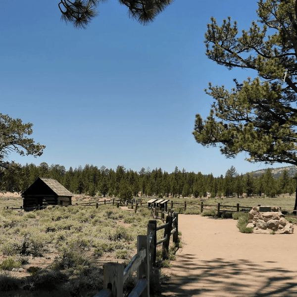
The San Bernardino National Forest surrounds Big Bear Lake and the San Bernardino Mountains offering some of California's most accessible mountain wheeling. At elevations ranging from 7,000 to over 9,000 feet, these trails wind through pine forests, historic mining areas, and granite boulder fields. The area centers around the famous Holcomb Valley, where California's biggest gold rush outside of the Sierra Nevada once boomed. Big Bear provides excellent access to diverse OHV trails suitable for all experience levels, from beginner-friendly dirt roads to challenging rocky terrain with steep inclines.

It is not only the awesome trail system that brings people to the Big Bear area. Big Bear is a charming town with excellent restaurants, attractions, lodging, and more.
Big Bear Off-Road Trail Overview
Holcomb Valley Road: This scenic 26-mile trail winds through the historic Holcomb Valley, offering a glimpse into California's Gold Rush past. Along the route, you’ll find stunning views and generally easy trail conditions that are well-suited for stock 4WD vehicles. Most of the road can be navigated in 2WD, with only a few sections requiring 4WD engagement. It’s an excellent choice for families and those new to off-roading.
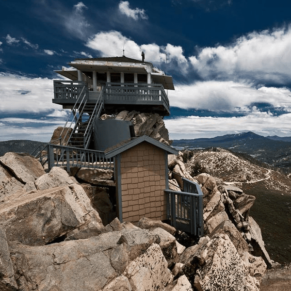
Butler Peak Road: This 10-mile mellow forest road climbs steadily to the communication towers atop Butler Peak, offering panoramic views of the San Bernardino Mountains and glimpses of Big Bear Lake. The well-maintained dirt surface is accessible for most SUVs and provides excellent photo opportunities without any technical obstacles.
Gold Mountain: This 12-mile out-and-back trail features moderate technical sections and rewarding summit views. The route includes rocky climbs and can become muddy during the snowmelt season. It’s a solid step up from beginner trails, offering a more challenging experience that remains manageable for moderately experienced drivers seeking added adventure.

White Mountain: This scenic 7.5-mile intermediate trail winds up White Mountain, offering several overlooks of the valley below. The route features loose rock sections and moderate grades that require solid throttle control and careful line selection.
Burns Canyon: This 18–20 mile forest trail winds through Burns Canyon, surrounded by dense pine trees. Expect seasonal water crossings and occasional rocky sections that add just enough challenge to keep the drive engaging—without the risk of getting stuck.
John Bull: This 5.5-mile trail is widely regarded as the most difficult in the Big Bear area, featuring large boulder obstacles and steep inclines that can take 2–4 hours to complete. The route requires high-clearance, short-wheelbase vehicles, and lockers are strongly recommended. The most technical section spans 2.2 miles of continuous boulders and rock gardens. This trail is not suitable for stock vehicles and begins with challenging terrain right from the start.
Holcomb Creek: This 8.5-mile hardcore trail winds along Holcomb Creek, beginning with “The Rock Garden” — a boulder field that sets the tone for the challenging terrain ahead. The route features multiple creek crossings, technical root sections, and deep moguls that will test even well-built rigs. Plan for a slow, deliberate ride through this demanding trail.
Dishpan Springs / Crab Flats: This 4-mile challenging mountain trail connects to the Crab Flats area and features steep climbs, off-camber sections, and potential snow conditions at higher elevations. The route combines technical difficulty with remote mountain scenery and requires careful navigation to complete.
As California’s largest state park, Anza-Borrego Desert State Park spans over 600,000 acres and offers more than 500 miles of dirt roads through diverse desert terrain. Only street-legal vehicles are allowed, making it ideal for adventure-ready trucks and SUVs. The landscape features everything from narrow slot canyons and rugged badlands to ancient palm groves and high mountain passes. This vast desert park delivers some of Southern California’s most spectacular views and challenging off-road opportunities across varied terrain.

Anza Borrego Off-Road Trail Overview
Font’s Point: Font’s Point Trail offers easy access to one of the best viewpoints in Anza-Borrego, with sweeping vistas of the Borrego Badlands, Vallecito Mountains, and Borrego Valley. The 4-mile route follows Font’s Wash from Highway S22, with the trailhead located 10.3 miles east of Christmas Circle in Borrego Springs, near mile marker 29. While the trail is often passable in 2WD, 4WD is recommended due to soft sand conditions. This classic desert overlook is a favorite among off-roaders and provides stunning sunset views.

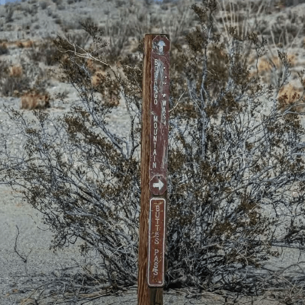
Buttes Pass Road: Buttes Pass Road is a scenic 3.6-mile point-to-point route through the Borrego Badlands, showcasing some of Anza-Borrego’s most unique geological formations. Accessed from Highway 78, the trail runs north toward Borrego Mountain, winding past colorful mud hills and offering excellent photo opportunities of the desert’s sculpted terrain. The road also provides access to The Slot canyon and is suitable for high-clearance 2WD or 4WD vehicles.
Arroyo Tapiado (Mud Caves access): This 9.1-mile point-to-point trail leads to one of Anza-Borrego’s most popular attractions—a network of slot canyons and mud caves carved into the region’s soft hills. Access is via S2 to Vallecito Creek Road, then 4.4 miles along the wash to the trailhead. The area contains 22 known caves and 9 slot canyons, with some caves stretching over 1,000 feet. These formations offer a cool escape from the desert heat and an unforgettable opportunity to explore the park’s rare geologic features on foot.
Fish Creek Wash to Sandstone Canyon: This 47-mile out-and-back trail (24 miles one-way) is a gateway to some of Anza-Borrego’s most iconic off-road destinations. The route passes through the towering walls of Split Mountain Canyon and provides access to Sandstone Canyon—one of the park’s most dramatic slot canyons. Expect washboard surfaces and occasional deep sand, making 4WD strongly recommended. This scenic yet challenging route highlights the region’s stunning geological features and desert beauty.

Calcite Mine Road: Calcite Mine Road is a 4-mile moderate desert trail that climbs into the Coyote Mountains, leading to the site of historic calcite mining operations. The route features rugged desert scenery and unique geological formations, with some rocky sections that require careful line selection. It’s a great option for off-roaders interested in exploring both the natural landscape and the area’s mining history.
Canyon Sin Nombre: Spanish for "Canyon Without a Name," this trail winds through colorful badlands and layered geological formations. The route includes technical wash crossings and provides access to more remote areas of Anza-Borrego, making it ideal for drivers seeking solitude and off-the-beaten-path adventure.
Pinyon Mountain Road (Heart Attack Hill and The Squeeze): This challenging 17.6 mile out-and-back mountain trail runs from State Route S-2 (4.4 miles south of Highway 78) near Shelter Valley to Pinyon Wash. The infamous "Heart Attack Hill" - a steep, loose climb that tests traction and driver skill, and "The Squeeze" - tight maneuvering between rock walls that can challenge wider vehicles. Total adventure requires 20-25 miles including exit via Fish Creek Wash.

Diablo Drop-Off (via Arroyo Seco del Diablo to Fish Creek): This approximately 13-mile route starts from S-2 near Canebrake and follows Arroyo Seco del Diablo ("Devil's Dry Wash") to a steep drop-off from a mesa into the Carrizo Badlands. This advanced route requires navigation of steep, rutted terrain and connects different trail systems, offering serious technical challenges for experienced drivers.
The Calico Mountains including the Calico Ghost Town Regional Park near Barstow combine Wild West history with challenging desert wheeling. These trails wind through the remains of a silver mining boom town while offering technical rock crawling and scenic desert mountain views.

Calico Ghost Town Off-Road Trail Overview
Mule Canyon Road: This gentle 8.7-mile point-to-point trail starts from I-15 at Calico Road near Yermo, heading north about one mile to the well-marked trailhead. Following historic mining routes through colorful desert terrain, this family-friendly trail offers glimpses of old mining structures and desert wildlife without significant technical challenges.
Wall Street Canyon (through-route): This 15.1-mile point-to-point scenic route through Wall Street Canyon starts from I-15 at Calico Road near Yermo via Mule Canyon Road. The main route through Wall Street Canyon provides scenic desert mountain driving with moderate difficulty, showcasing the area's mining history while remaining accessible to stock high-clearance vehicles.
Phillips Loop: This 11.0-mile loop trail near Yermo combines desert washes with rocky climbs through the Calico Mountains, starting from I-15 at Calico Road near Yermo via Mule Canyon Road. This moderate route offers varied terrain and can be combined with other trails for longer adventures.
Doran Canyon (incl. "Doran Gatekeeper"): This technical 6.2-mile loop trail starts from I-15 at Ghost Town Road, continuing north 3.5 miles past Calico Ghost Town entrance. The challenging "Doran Gatekeeper" serves as a difficult rock obstacle entrance exam for the canyon's toughest sections.
Odessa–Doran Loop: This advanced 6.2-mile loop starts from I-15 at Ghost Town Road (3.5 miles north past Calico Ghost Town), combining multiple technical sections with remote desert scenery. Odessa Canyon can also be treated as a standalone 3.5-mile out-and-back with 500 feet elevation gain. This challenging route requires well-equipped vehicles and experienced drivers.

Phillips Canyon (West): The western section of Phillips Canyon offers the most technical challenges in the Calico system, accessed via the main Calico trail network from I-15 at Calico Road near Yermo. This route features steep rocky climbs and narrow passages that demand precise driving skills.
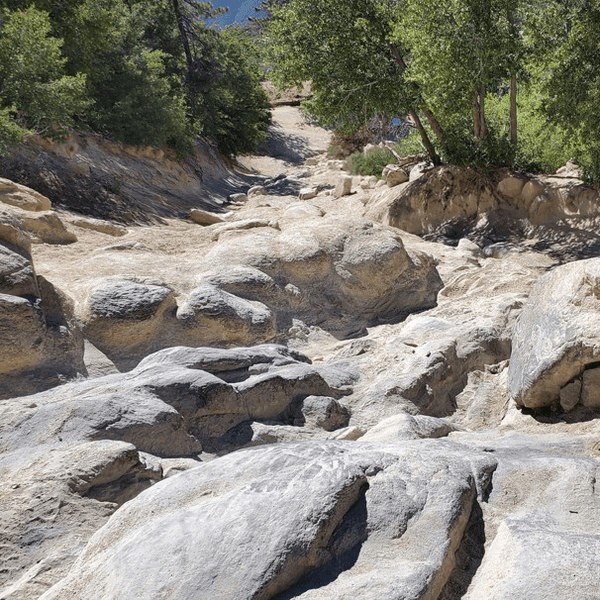
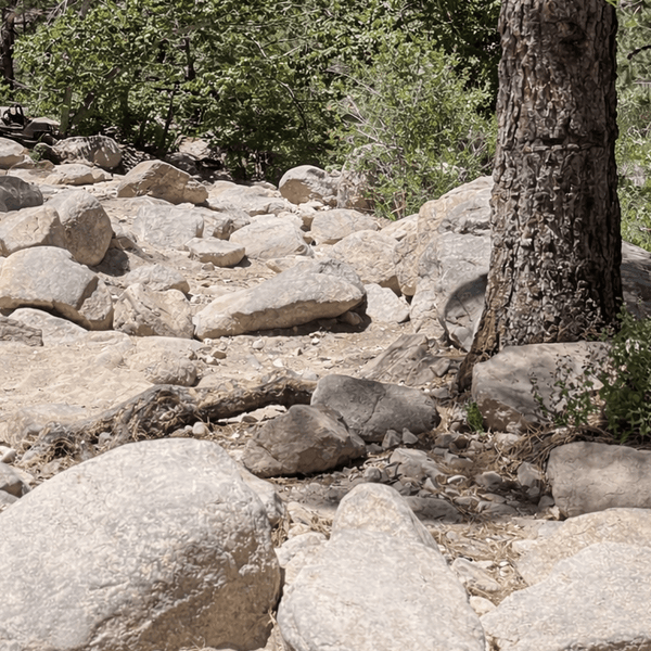
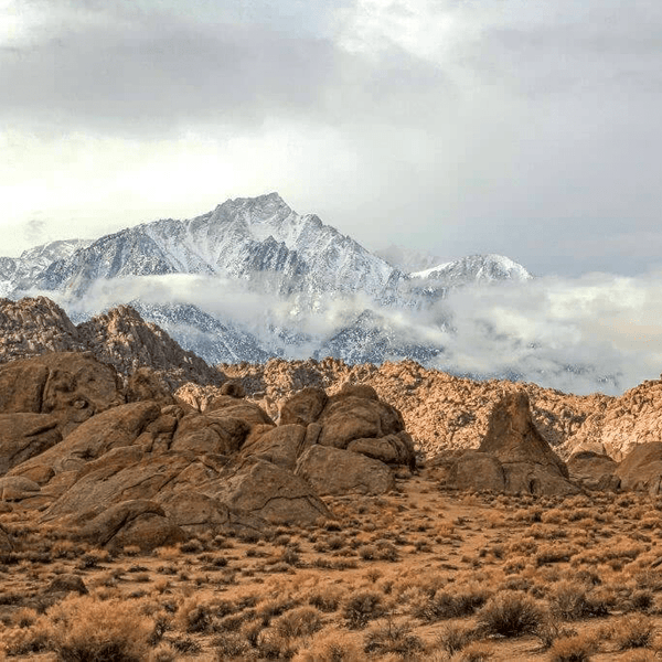
Set against the dramatic backdrop of Mount Whitney, the Alabama Hills offer a unique combination of distinctive rock formations, Hollywood history, and Sierra Nevada views. These trails wind through granite boulder fields where countless Western movies were filmed.

Movie Road / Movie Flat: The main route through the Alabama Hills Recreation Area runs 2.3 miles from the turnoff on Whitney Portal Road (located 2.7 miles west of Lone Pine), passing famous rock formations featured in countless Hollywood productions. This well-maintained dirt road offers spectacular views and interesting geological features with minimal difficulty, showcasing distinctive rock formations where countless Western movies were filmed.

Mobius Arch Trailhead Spur: A short spur leading to the trailhead for the popular Mobius Arch hike. The easy drive provides access to one of the area's most photographed natural arches with Mount Whitney visible through the opening.
Boot Arch & Shark Fin spurs: Several short side trails lead to distinctive rock formations including Boot Arch and Shark Fin Rock. These easy routes offer close-up views of the area's unique granite sculptures.
Hogback Road (Movie Rd to/from Whitney Portal Rd): Hogback Road is an intermediate trail that connects Movie Road and Whitney Portal Road by climbing over a scenic ridge. The route offers elevated views of the Sierra Nevada and Owens Valley, making it a worthwhile detour for those exploring the Alabama Hills area. Mild technical sections and moderate elevation changes make this trail suitable for high-clearance vehicles.
Moffat Ranch Road (north connector): This moderate trail connects the northern reaches of the Alabama Hills, traversing a mix of desert flats and granite boulder fields. Moffat Ranch Road offers a quieter alternative to more trafficked routes while still providing classic views and varied terrain. Suitable for high-clearance 2WD or 4WD vehicles.
North Alabama Hills Vista area spurs: Located in the northern section of the Alabama Hills, these spur trails lead to elevated viewpoints and striking rock formations. Less traveled than the main Movie Road loop, these routes offer greater solitude and unique vantage points of the surrounding landscape. Ideal for drivers looking to explore off the beaten path.
Johnson Valley gained worldwide fame as home to the King of the Hammers race, the world's toughest off-road competition. This 96,000-acre OHV area located 55 miles southeast of Barstow, accessed via Highway 247 at Old Woman Springs Road or Camp Rock Road, combines high-speed desert racing terrain with technical rock crawling sections. The area includes both open desert runs and technical rock gardens, making it a premier destination for off-roading adventures.

Johnson Valley Off-Road Trail Overview
Hammers Scenic Byway: This designated scenic route follows portions of the legendary King of the Hammers race course. While the terrain is surrounded by extreme off-road trails, the Byway itself is a maintained road accessible to stock vehicles. It offers dramatic views of the surrounding desert landscape and nearby mountain ranges, making it a great option for those looking to explore the area without tackling technical obstacles.
Means Dry Lake & "Road to the Hammers": These easy desert trails lead to the iconic Means Dry Lake and provide access to spectator areas during major King of the Hammers events. The wide, open terrain features minimal technical challenges and offers expansive views of the surrounding race course and desert. Suitable for stock vehicles and ideal for first-time visitors.
Anderson Dry Lake area: Flat desert trails surround Anderson Dry Lake, offering easy access for exploration and dispersed camping. Located approximately 10 miles north of Highway 247 and east of Camp Rock Road, this area is popular with off-road groups and overlanders looking for a base camp with open space and easy trail connections.
Claw Hammer: Claw Hammer is a moderate trail that features the granite rock sections that have made Johnson Valley famous. It offers a taste of the area's technical terrain without the extreme difficulty found on more advanced routes, making it a solid option for drivers looking to sharpen their skills.
Aftershock: Named after a section of the King of the Hammers racecourse, Aftershock is an intermediate trail that blends desert washes with rocky climbs. Drivers should expect to use careful line selection and throttle control to navigate the terrain successfully.
Turkey Claw: Turkey Claw is a moderately challenging trail that showcases Johnson Valley’s unique mix of open desert and granite obstacles. The route includes scenic overlooks and notable geological formations, offering both technical fun and visual rewards.
Fissure Mountain: This trail climbs toward Fissure Mountain through varied desert terrain and offers sweeping views of the surrounding valley. Moderate technical sections and elevation changes provide a rewarding challenge for capable off-road vehicles.
Sledgehammer: One of the most infamous sections of the King of the Hammers course, Sledgehammer features extreme rock crawling over massive granite boulders. This highly challenging trail requires heavily modified vehicles and expert driving skills. The terrain includes steep inclines and technical obstacles that can quickly overwhelm unprepared rigs.
Jackhammer: A King of the Hammers classic, Jackhammer combines high-speed desert stretches with demanding rock gardens. This route requires vehicles built to handle both fast-paced racing and slow-speed crawling over rugged terrain, making it a true test of versatility and driver control.
Wrecking Ball: Wrecking Ball is a brutal trail packed with large boulders, steep climbs, and tight lines. Named for its tendency to break underbuilt rigs, this route should only be attempted by experienced teams equipped with proper recovery gear and the skills to navigate technical rock crawling terrain.
Outer Limits: True to its name, Outer Limits presents extreme technical challenges that push both vehicles and drivers to their breaking point. Known for housing some of Johnson Valley’s most difficult obstacles, this trail demands expert-level off-roading experience and fully built rigs.
Chocolate Thunder: Chocolate Thunder is a legendary technical trail known for its punishing rock sections, steep climbs, and high risk of vehicle damage. A popular testing ground for competitors ahead of major races, it attracts crowds during events but remains a serious challenge best suited for experienced drivers.
Joshua Tree National Park is a world-renowned destination known for its striking desert landscapes, iconic Joshua trees, and diverse geology. Covering nearly 800,000 acres in Southern California, the park is located where the Mojave and Colorado Deserts converge, offering a mix of rugged rock formations, sandy washes, and scenic backroads. While not a designated OHV area, Joshua Tree provides access to several unpaved trails suitable for high-clearance and 4WD vehicles, making it a popular spot for scenic overlanding, hiking, and desert exploration.

Queen Valley Roads (Queen Valley Rd, Big Horn Pass Rd, O'Dell Rd): This 13.4-mile network of scenic dirt roads winds through Queen Valley and can be accessed from Barker Dam or Big Horn Pass, across from Geology Tour Road. These routes offer excellent wildlife viewing and highlight the area's unique desert ecosystem. With no technical obstacles, they are suitable for most high-clearance 2WD vehicles.
Geology Tour Road (first miles): The beginning section of this interpretive route starts 2 miles west of Jumbo Rocks Campground. The first 5.4 miles to Paac Kü̱vü̱hü̱'k are mostly downhill but can be bumpy and sandy in spots. This portion offers easy desert driving along with educational stops that explain the region's unique geological features.
Geology Tour Road (full loop): The complete 18-mile route combines the initial 5.4-mile section with a 6-mile loop exploring Pleasant Valley, starting 2 miles west of Jumbo Rocks Campground. This self-guided tour offers more challenging sections with washboard surfaces, sandy washes, and some rocky areas.
Covington Flat Roads to Eureka Peak: This 3.8-mile one-way route runs from Lower Covington Flat picnic area to Eureka Peak, with an additional 6.5 miles to Upper Covington Flat backcountry trailhead. A moderate climb through Joshua tree forests to elevated viewpoints offering cooler temperatures and panoramic desert views.
Old Dale Road: This challenging 23-mile road starts at the same point as Black Eagle Mine Road, with the first 11 miles across Pinto Basin containing sections of deep sand. A historic mining road that provides access to remote areas, featuring challenging washes, rocky sections, and requiring good navigation skills.
Berdoo Canyon Road: This technical 11.5-mile road travels through Berdoo Canyon, connecting the south end of Geology Tour Road with Dillon Road. Features steep grades, loose surfaces, and narrow passages with deep sand, sharp bedrock, and rough boulders.
Pinkham Canyon & Thermal Canyon Roads: This challenging ~20-mile road network starts west from Cottonwood Visitor Center, offering several route options through varied terrain from sandy washes to rocky climbs. Features rough boulders, deep sand, and a pinch point that may be impassable to larger vehicles.
Black Eagle Mine Road: Beginning 6.5 miles north of Cottonwood Visitor Center, this dead-end dirt road runs 9 miles within park boundaries along the edge of Pinto Basin. Features some of the deepest sand in the park, steep and loose wash-crossings, and leads to historic mining sites requiring caution.
The Mojave Desert is a vast and rugged landscape renowned for its remote terrain, historic routes, and iconic desert scenery. Covering over 25 million acres across Southern California, Nevada, Arizona, and Utah, it includes legendary areas like the Mojave National Preserve and stretches of the historic Mojave Road. Off-roaders flock to this region for its expansive trail networks, sandy washes, lava tubes, Joshua tree forests, and abandoned mining sites. With routes ranging from easy overland paths to technical rock sections, the Mojave is a premier destination for backcountry exploration, offering solitude, challenge, and unmatched desert views.

Black Canyon Rd to Cedar Canyon Rd (Hole-in-the-Wall): A scenic route connecting two of the preserve's most interesting geological features, accessible via various preserve roads. This easy trail passes through varied desert terrain with opportunities to explore unique rock formations.
Kelso Dunes Access: This 4-mile refined dirt road starts from Kelbaker Road (15 miles north of I-40 Exit 78) and leads to the trailhead at the impressive Kelso Dunes. Easy desert roads leading to some of the tallest sand dunes in the Mojave Desert, offering unique landscape photography opportunities.

Mojave Road (classic overland route): This historic 137.5-mile trail runs from near Needles, California to near Barstow, following the ancient trail used by Native Americans and Spanish expeditions. The route stretches from Beale's Crossing on the Colorado River to Afton Canyon near Barstow, crossing varied desert terrain. Individual sections can be tackled as day trips.
Caruthers Canyon Road (New York Mountains access): A moderate trail climbing into the New York Mountains via the preserve's road system, offering cooler temperatures and different vegetation zones. Features some rocky sections and provides access to historic mining areas.
Aiken Mine Rd to Lava Tube: An interesting geological trail leading to lava tube formations in the Cinder Cone National Natural Landmark, accessible via preserve roads. Combines moderate off-road driving with unique volcanic features to explore.
Afton Canyon (Mojave River crossings): Part of the historic Mojave Road, accessed from I-15 Exit 221 (Afton Road) with a 3.5-mile graded dirt road to the canyon floor. Known as the "Grand Canyon of the Mojave," this trail includes multiple river crossings through spectacular canyon country requiring careful navigation.

Macedonia Canyon: A remote and challenging canyon trail accessible via the preserve's backcountry road system, requiring excellent navigation skills and self-sufficiency. Features technical rocky sections and requires multiple days for full exploration.
Getting the most out of your Southern California off-road experience requires proper preparation and the right mindset. Here are the essential elements for safe and successful trail adventures.
Research trail conditions, seasonal closures, and permit requirements before you head out on your adventure. Many areas require Adventure Passes or camping permits. Download offline maps and GPS tracks, as cell service can be spotty in remote areas. Plan for adequate time to complete your chosen route safely.
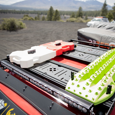
Make sure your vehicle is trail-ready with proper tires, recovery points, and essential tools. Carry spare parts specific to your vehicle and terrain. Consider upgrading suspension, skid plates, and adding lockers for more challenging trails. Check your wheels and tires before every ride. Never travel without a full-size spare and the tools necessary to change a spare while on the trail.
Bring recovery gear including tow straps, shackles, and a shovel. Pack extra water, food, first aid supplies, and emergency communication devices such as a HAM radio. A well-stocked tool kit and vehicle fluids are essential for remote adventures. Don't forget supplies for summer heat or winter months conditions.
Download offline maps and GPS coordinates. Carry paper maps as backup. Invest in satellite communicators for areas without cell coverage. Share your route and timeline with someone reliable before you head out.
Travel in groups when possible, especially on challenging trails. Yield to uphill traffic and larger vehicles. Stay on designated road trails to protect fragile desert ecosystems. Pack out all trash and respect private property and federal agency rules and regulations including BLM land regulations and US Forest Service regulations.
Follow Leave No Trace principles adapted for motorized recreation. Stay on established trails to prevent erosion and habitat damage. Camp only in designated areas. Respect wildlife by observing from a distance and avoiding nesting areas during breeding seasons.
Southern California's off-road trails offer endless adventures for every skill level and experience level. From technical rock crawling to scenic desert tours, these diverse landscapes provide the perfect playground for off-road enthusiasts. Keep in mind that trail conditions change with weather and seasons, so always check current conditions and respect closures designed to protect both the environment and your safety.
Whether you're just starting your off-road journey or you're a seasoned veteran looking for your next challenge, Southern California's incredible variety of terrain guarantees you'll never run out of new places to explore and discover. From the proximity of Lake Arrowhead to the remote desert of Ocotillo Wells, these trails offer fun for everyone. Grab your gear, fuel up your rig, and head out to explore why Southern California is truly a 4x4 paradise with some of the most amazing trails in the country.
Comments will be approved before showing up.