Your Cart is Empty


Burns Canyon Trail doesn't look like much on a map. A squiggly line connecting the high desert to Big Bear. But drive it once, and you'll get why locals have been using this route for decades. Last fall, I ran it with a couple of buddies who'd just bought their first rigs. Started in Pioneertown (near Pappy & Harriet's), ended up two hours later in the pines at 7,500 feet. That's Burns Canyon. A fun day trip connecting two totally different worlds.
You'll climb nearly 3,000 feet over roughly 24 miles, from the desert floor up through San Bernardino National Forest. The Burns Canyon Trail runs from Pioneertown (or nearby Rim Rock) to Baldwin Lake on the Big Bear side. Moderate difficulty most of the way, with a few rocky sections. Perfect for testing a new rig or getting comfortable with off-roading. Here's everything you need to know about the trail before tackling it.
Looking for other Big Bear trails? Check out our Big Bear Off-Road Trail Guide
Burns Canyon Road (Forest Service Road 2N02, also called Arrastre Creek or Burns Canyon Rd) follows old mining and ranching routes from the late 1800s. Locals from Big Bear used this route to cut across to Yucca Valley and Palm Springs before modern highways existed. The trip through the mountains connected desert communities to mountain towns for years.
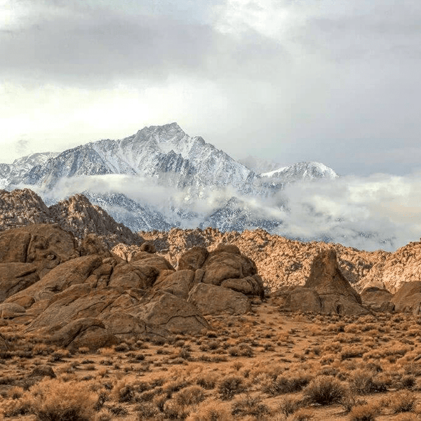
The trail passes through the San Bernardino National Forest, connecting the Mojave Desert to the mountain forest in the San Bernardino area. Down low, you're in Joshua trees and creosote. As you climb, vegetation shifts through chaparral, then pinyon pine, eventually to ponderosa forest up top.
Pioneertown is worth mentioning. Built in the 1940s as a movie set for Westerns, it's now a quirky desert community with Pappy & Harriet's restaurant and that old-timey main street. Starting or ending there and exploring the town a bit is definitely worth it.
Most people start from the desert side location. From Yucca Valley, take Pioneertown Road north about 4 miles to Pioneertown. The trailhead for Burns Canyon Road (2N02) is just northwest of town. Air down near the post office or at the start of the dirt. Lower elevation starting point around 3,300 feet.

Starting here means climbing the whole way. The steep hills and rocky sections are easier going uphill, where you can use momentum.
There are also access points from Yucca Valley itself. The Burns Canyon area has multiple connecting roads. Stick to marked Forest Service roads in the area.
The upper end comes out near Baldwin Lake, east of Big Bear Lake. From here, you can head west to Big Bear Lake proper, or east to Holcomb Valley if you're continuing on other trails in the area.
Starting from the Big Bear side means descending the technical sections. If it's your first time, go up from Pioneertown.
Burns Canyon runs about 20 miles one-way, though different GPS tracks and maps show anywhere from 18 to 24 miles depending on exactly where you start and end. Figure on 2 to 3 hours of actual trail time if you're moving steadily. Add time for photos, air down/up, and any breaks.
Difficulty sits around 2-3 out of 10 for most of the road, spiking to maybe 5 out of 10 on the rockier drainage crossings and rutted climbs. This isn't a hardcore trail, but it's not a graded dirt road either. It's moderate and challenging in different spots. You need a capable vehicle and basic off-road skills.

The route is drivable year-round except during winter when snow closes the upper sections. Spring and fall are ideal. Summer gets hot down low (easily 100+ degrees in the desert), but stays comfortable once you gain elevation. Late spring after good winter rains can leave lingering mud and washouts.
Burns Canyon starts easy and builds. Lower canyon from Pioneertown is mostly sandy washes with mild embedded rock. Maintain momentum through sandy spots. 4WD helps, but isn't always necessary down here on this section of the trail.
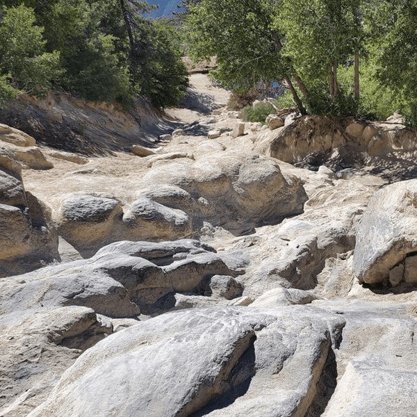
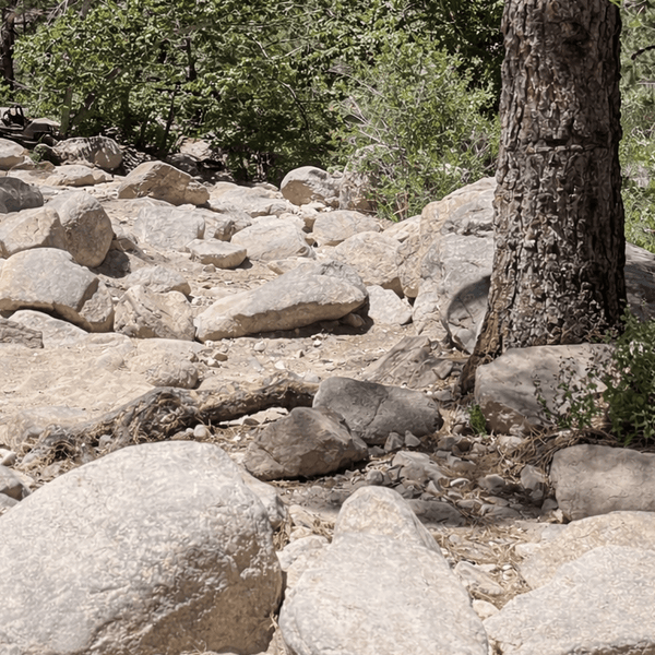
Mid-canyon gets interesting. The trail climbs more aggressively with embedded rock, loose sections, and rutted areas. This is where people who skipped airing down regret it. A couple of rocky drainage crossings look worse than they are. You'll hit some large boulders and navigate around them. Pick your line, commit, keep moving.
Forest switchbacks appear as you climb through steep hills. Trail narrows, trees close in, tighter turns with drop-offs. Not dangerous if you're paying attention, but keep speed down and watch for oncoming traffic. The drop on some corners will get your attention. Blind corners mean being ready to stop or back up.
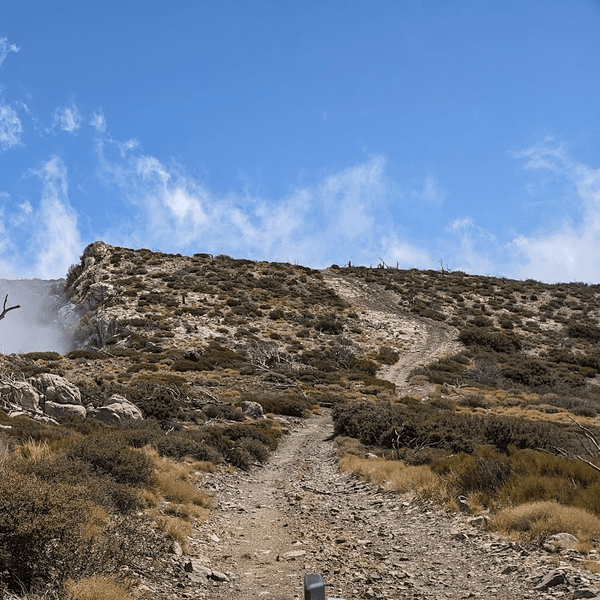
Upper plateau sections near Baldwin Lake smooth out to well-maintained dirt roads. Cruise a bit and enjoy the pine forest scenery on this easier part of Burns Canyon.

The classic approach is the way most people run Burns Canyon Trail. Start in Pioneertown, air down, run up to Baldwin Lake, air back up. Takes a half day. Check your map before you start.
Who it's for: Anyone with a stock 4x4 looking for moderate trails. Families, new off-roaders, groups testing fresh builds.
Once you're up at Baldwin Lake, continue and connect to Holcomb Valley trail system. This route connects Burns Canyon to historic mining areas. Check out the old ghost town locations, maybe link to other moderate trails.
This turns a 2-hour trip into a 4-5 hour adventure. Many people drove this combo route over the years.
Who it's for: People who want to maximize their day in the mountains.
Link Burns Canyon Trail with Holcomb Valley, then connect to other trail systems like Gold Mountain or White Mountain. You're looking at 50-60 miles, creating a full-day Big Bear experience.
Requires solid navigation, two vehicles for safety, and rigs ready for varied terrain. The entire loop takes most of the day.
Who it's for: Experienced overlanders and off-road groups.
|
Section |
What You'll Encounter |
Driver Notes |
|
Lower Canyon |
Sandy washes and mild rock |
Maintain momentum through sand |
|
Mid-Canyon Climbs |
Embedded rock and loose traction |
Airing down recommended |
|
Forest Switchbacks |
Narrow turns and shade |
Watch downhill traffic |
|
Upper Plateau |
Smoother dirt roads |
Scenic cruising |
The mid-canyon climbs are where most people get their first real off-roading moment on Burns Canyon. One section with deep ruts bottomed out my buddy's truck, even with 3 inches of lift. He had to engage his rear locker to climb out. Just requires the right line and sometimes the right equipment.
Forest switchbacks feel tight. If you meet someone coming the opposite direction, someone's backing up. Downhill traffic yields. It's easy to find yourself in a tight spot if you're not careful. Take your time and choose the way that works for your rig.
I've seen stock 4Runners and Tacomas make it through Burns Canyon. The key is picking good lines and not rushing. If you're marginal on clearance, be extra careful in the rutted sections. You'll need to maneuver around obstacles and choose your lines carefully.
This setup gives you confidence to handle anything Burns Canyon throws at you without worrying about damage. Study the map ahead of time to know what's coming.
The scenery shift is the main attraction on Burns Canyon Trail. Joshua tree desert transitioning to pine forest over 20 miles is impressive. Stop at viewpoints looking back toward the Mojave for photos. The view from higher elevations shows the desert floor below.

Old Rose Mine sits along the route, though actual workings are fenced off. Quick historical marker stop is worth checking out.
Recreational shooting sites (Arrastre 1 and 2) are along the way. You'll hear gunfire if they're active.
Wildlife includes deer, coyotes, and occasionally bighorn sheep in the lower rocky areas along Burns Canyon.
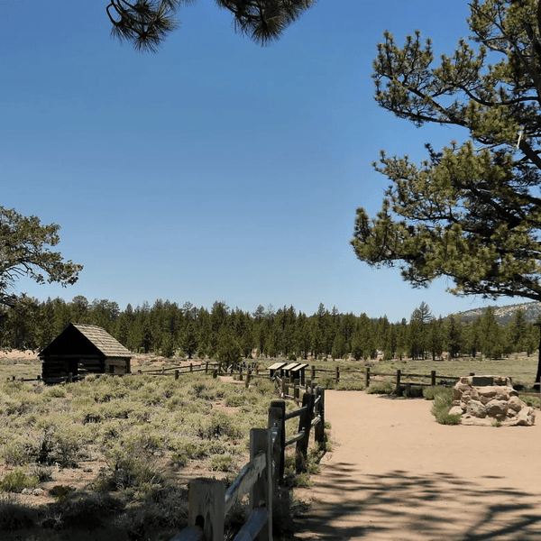
Dispersed camping is allowed in the San Bernardino National Forest following standard rules. Once you're up in the forest sections of the mountain area, there are spots to camp. Baldwin Lake area and Holcomb Valley both have established dispersed sites in this part of the national forest.
Pioneertown has limited services, but Pappy & Harriet's is a must-visit for food and drinks. The vibe is worth experiencing.
Big Bear has full services, developed campgrounds, and all the mountain recreation you could want in the area. Serrano Campground is closest to the Baldwin Lake side.
Yucca Valley and Joshua Tree National Park are nearby if you're making a weekend of desert exploring. Worth a visit either before or after running Burns Canyon.
Burns Canyon Trail shows up on most off-road GPS apps as Burns Canyon Road. OnX Offroad, Gaia GPS, and AllTrails all have it mapped. Download offline maps before you go. Cell service is hit or miss throughout the route.
The trail is generally well-defined and easy to follow. A few spots have multiple spurs, but the main road route is obvious if you're watching your GPS track and map.
Current conditions vary by season. Call San Bernardino National Forest at (909) 382-2790 for updates on closures or problem areas. Winter snow closes the upper sections typically from December through April. Check conditions before you head out. Summer thunderstorms can create temporary washouts.
The best time to run Burns Canyon Trail is March through May (spring) or September through November (fall). Summer works, but it's hot on the desert end of the trail. Winter is iffy with snow.
Stay on the marked trail and road. There are private residences scattered along Burns Canyon, so respect property boundaries.
Pack out everything. Desert and forest both show trash forever.
Uphill traffic has the right of way on Burns Canyon Trail. If you're descending and meet someone climbing, back up or pull over to a wide spot.
Keep speeds reasonable. You're sharing this road with locals who live here.
If you see active shooting at the recreational sites, give them a wide berth, stop if needed for safety, and keep moving.
Burns Canyon Trail delivers exactly what it promises. A scenic, moderately challenging route connecting two completely different worlds. You're not going to break your rig unless you do something dumb, but you'll definitely get a taste of real off-roading on this trail. The elevation gain, scenery change, and mix of terrain make Burns Canyon one of Southern California's best beginner-to-intermediate trails.
Whether you're shaking down a new build, introducing friends to off-road driving, or just looking for a fun day out of the city, Burns Canyon works perfectly. Add Pappy & Harriet's on one end and Big Bear on the other, and you've got a proper adventure worth the trip. Plan to visit both ends to get the full experience.
Before you head out, make sure your rig is ready. At Truck Brigade, we have gear, parts, and accessories for 4x4 vehicles and other adventure vehicles with exactly what you need for trails like Burns Canyon Trail.
Our team runs these trails ourselves, so feel free to reach out if you have questions about a certain build in mind or a budget you'd like to work with. Visit truckbrigade.com to get your rig dialed in for Burns Canyon and beyond.
Comments will be approved before showing up.


Jorge Vargas
March 03, 2026
Hello. I’m new to off-roading and would be doing this trail with a buddy with experience. I have a stock F150 Tremor. Would this rig be too big for the tight sections or should I be fine? Will the stock suspension be adequate to handle rocky and rutted sections as well? Thanks for any info you can provide!